Electrical Resistivity
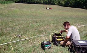
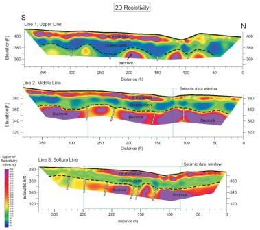
The resistivity method measures the apparent resistivity of the subsurface, including effects of any or all of the following: soil type, bedrock fractures, contaminants and ground water. Variations in electrical resistivity may indicate changes in composition, layer thickness or contaminant levels. The resistivity method is useful for simultaneously detecting lateral and vertical changes in subsurface electrical properties. Electrical resistivity is also used to delineate 3-dimensional structures with anomalous electrical conductivities. Depending on the client’s need, Hager-Richter uses traditional Vertical Electrical Sounding (VES) and lateral profiling methods as well as state of the art 2-D imaging techniques to produce the best results for any situation. The use of rapid, automated data acquisition systems used to create 2-D “tomograms” has increased the flexibility of resistivity as a tool for environmental and geotechnical applications.
Since no two projects are alike, the depth and diversity of our experience provide distinct advantages for our clients.
Electrical resistivity surveys have certain limitations. They may be unsuitable for examining highly industrialized and/or urbanized areas where cultural features such as buildings, fences, and power lines may interfere with acquisition of accurate data. The target depth, size and, of course, resistivity contrast may pose limitations.
We can provide you with an accurate assessment of your requirements to determine whether or not the use of the resistivity method is appropriate at a particular site.
General Applications
- Environmental audits and site assessment
- Water resource management
- Groundwater resource studies: mapping and plume delineation
- Public/Private remedial investigations and feasibility studies
- Landfill closures geological mapping
Specific Applications
- Determine electrical characteristics of surrounding area
- Determine depth of water table
- Detect contaminant plumes
- Detect fracture zones and faults
- Determine extent of Karst features
- Detect areas of potentially unstable ground, e.g. mine shafts, sinkholes, voids
- Assist in dam stability analysis
- Determine overburden depth
- Locate buried mafic dikes
- Provide data for corrosion control design
- Determine lithology/structure