Ground Penetrating Radar
Ground Penetrating Radar (GPR) operates like other, more familiar radar systems such as police or weather radar.
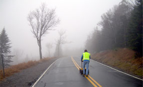
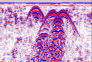
As the GPR antenna is moved across the surface, it transmits electromagnetic signals into the subsurface and receives reflections from interfaces in the path of the signal at which changes in the electrical properties (dielectric constant) of the subsurface materials occur. The reflections are then amplified, processed, and displayed on a screen and recorded digitally for post processing and/or printing. GPR provides a continuous profile of the subsurface.
GPR allows for the acquisition of large amounts of data in a short period of time, making it a cost-effective method for many projects. GPR is commonly used in conjunction with other geophysical techniques such as magnetic, electromagnetic induction, and seismic refraction.
Experience and equipment are critical to derive the full benefit from the ground penetrating radar technique. At Hager-Richter, we have the experience and resources to provide you with reliable guidance and accurate data.
Experience is crucial in the analysis and interpretation of GPR data, and especially in evaluating the feasibility of GPR investigations where site-specific limitations are present.
Our state-of-the-art equipment complements our experience, often overcomes site limitations, and enhances the quality of our work. We own a full complement of antennas for different resolutions and exploration depths. Our real time display allows us to compensate for amplitude differences and quickly adjust our field procedures to optimize the data. Our survey wheel automatically triggers the placement of markers at equal intervals, thereby increasing the accuracy of survey distances. The processing software we use allows us to modify the way data is displayed and to filter out extraneous noise, providing us with a clearer view of subsurface conditions through profiles, time slices, and 3D imaging.
General Applications
- Construction/engineering projects
- Environmental audits and site assessments
- Evaluation of active/inactive industrial sites
- Public/private remedial investigations and feasibility studies
- Geological studies
- Archeological studies
Specific Applications
- Determine the location, dimensions, and burial depth of drums, undergroundstorage tanks, and utilities

- Locate contaminant plumes
- Delineate waste pits, trenches, landfill edges
- Determine the locations of old foundations, possible archeological artifacts
- Locate voids in bridge decks, airport runways, dams, and roadways
- Determine water table and bedrock depths
- Detect sinkholes in karst terrain